Home |
Fluxpyr |
Research activities |
Participants |
Products |
Events |
News |
Photo gallery |
Press |
Education |
Opportunities |
Resources |
Links |
Intranet |
Contacts |
Site Map |
|
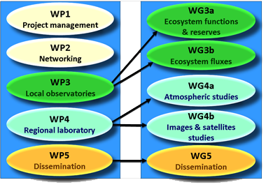
Fluxpyr >> Working groups FLUXPYR integrates ecosystem, atmospheric and satellite studies, and the work is organized in 5 complementary and multi-disciplinary Working Groups (WGs) corresponding to 3 Work Packages (WPs; WP1 and WP2 do not have associated Working Groups).
THE FIVE WORKING GROUPS (WG)
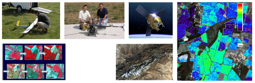
Working Group 3a: Ecosystem functions and reserves (Coordinator: Rosa Maria Canals, UPNA) Main Activities: Inventory of existing databases and protocols on carbon, water and biodiversity in the Pyrenees; construction of a complete database of ecosystem variables using the different existing databases (carbon, nitrogen, productivity, biodiversity, water); ecosystem surveys around the micro-meteorological stations installed to assess ecosystem productivity, biodiversity, respiration, photosynthesis, soil characteristics, etc.; characterization of agricultural practices (fertilization, soil management, etc.); study of the impact of fire (prescribed burning) on grassland ecosystems (effects on nitrogen and carbon cycles, productivity and biodiversity); development and comparison of empirical and mechanistic models for carbon spatialization, ecosystem productivity and biodiversity.
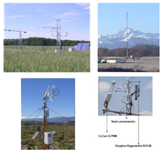
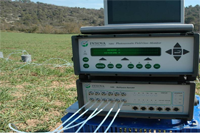
Working Group 3b: Ecosystem fluxes (Coordinator: Eric Ceschia, CESBIO) Main Activities: Setting-up of micro-meteorological stations on agricultural plots and grasslands at different altitudes (between 100 m and 2000 m); assessment of the local fluxes of carbon, water and energy (using eddy covariance stations and other sensors), discrete air sampling (CO2, N2O, CO, CH4, SF6); transfer of expertise and tools for flux calculations and advanced analysis: Net Ecosystem Exchange (NEE) partition, gap filling, sensitivity analysis, etc.; calculations of carbon and greenhouse gas budgets at local and regional scales.
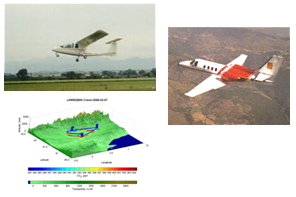
Working Group 4a: Atmospheric studies (Coordinator: Josep Anton Morguì, IC3) Main Activities: Study of regional CO2, water and energy fluxes; Airplane campaigns twice a year to measure the atmospheric CO2 concentration along horizontal and vertical profiles (between 300 m and 7500 m asl); use of Lagrangian models to study atmospheric transportation; Standardization of meteorological measurements (soil profiles).
Working Group 4b: Images and satellite studies (Coordinator: Agustin Lobo, ICTJA-CSIC) Main Activities: Elaboration of a catalogue of the imagery available for the region of study; review of existing remote sensing work related to carbon fluxes; creation of a guide on upscaling and downscaling techniques; study of the relation between high/low resolution imagery and carbon/water fluxes at CESBIO sites; exercise on the integration of LANDSAT/SPOT sequences with MODIS/VEGETATION time series; tuning of RGB (Red Green Blue) into CIR (Colour Infrared) camera; airborne remote sensing mission specifications; comparison of the dataset available since now in the Pyrenees with the new one; airborne campaigns above the Pyrenees to collect data (images, concentration profiles, etc.); study of land use, land cover and snow cover dynamics; estimation of the albedo effect associated to vegetation burning.
Working Group 5: Dissemination (Coordinator: Jean François Dejoux, CESBIO) Main Activities: efficient and regular communication of FLUXPYR activities: design of the logo, triptics, posters and website, newsletters write-up, conference organization, etc.; translations of dissemination and technical documents (Spanish, French, English and Catalan); creation of a directory of all the academic courses related to mountain environment (identification of the contents and teachers); set up of academic courses and proposition of thesis topics for graduate and postgraduate students (e.g. local actors and their perception of climate change; climate change and local practices); surveys of socio-economic and institutional actors involved in climate change studies; organization of workshops and exchanges between institutions; diffusion of the data and maps generated by FLUXPYR and their integration in an Open System Resources (OSR) website; study of the Open Geospatial Consortium (OGC) interoperability with the APEM GeoServer and OGC interoperability with a Spanish GeoServer (Miramon).
|
||||||||||||